Wallbrook Gold PROJECT

The 250km2 Wallbrook tenement package is considered highly prospective for the discovery of significant gold mineralisation.

Located 130km north east of Kalgoorlie

The Wallbrook tenement package covers 250km2 and is an amalgamation of tenements acquired from Newmont and Saracen Minerals in 2018.

In November 2018, Nexus completed a Tenement Sale and Purchase Agreement to acquire from Newmont the surrounding 190km2 tenement package adjacent to Nexus’ existing 60km2 Wallbrook Gold Project. Nexus acquired from Newmont the surrounding three tenements covering 190km2 for a total consideration of $13,100 and a 2% net smelter royalty on all mineral product extracted and recovered from the tenements (ASX release 29 November 2018 – Nexus Completes Wallbrook Tenement Acquisition from Newmont).

Nexus had previously acquired the central Wallbrook exploration tenements from Saracen, in January 2018 for consideration of 1,490,000 Nexus shares (ASX release 23 January 2018 – Nexus Wallbrook Gold Project Update). 

Regional and Local Geology

The Wallbrook Project occurs within the Norseman – Wiluna Archaean Greenstone belt in the Eastern Goldfields province of the Yilgarn Craton. The Project is located within the Edjudina Region in the Laverton Tectonic Zone, centrally between Kalgoorlie and Laverton, and 35km north of Northern Star Limited’s Carosue Dam Gold Mining Operation.

The granite-greenstone belt is approximately 600 kilometres in length and is characterised by thick, possibly rift-controlled accumulations of ultramafic, mafic, felsic volcanic, intrusives and sedimentary rocks. Greenstone successions of the southern Eastern Goldfields have been segregated into elongate structural terranes bounded by regional NNW-trending faults (Swager, 1995). These terranes include the Kalgoorlie Terrane, Gindalbie Terrane, Kurnalpi Terrane and the Edjudina Terrane. These terranes contain distinct similarities, including timing of the deposition of volcano-sedimentary sequences (2720-2675 Ma) and regional deformation and plutonism (2675-2620 Ma). The terranes differ only in lithostratigraphic development and early tectonic history (Swager, 1995).

The Wallbrook Project area is located between two major converging tectonic features, the Laverton and Keith-Kilkenny tectonic zones. The Laverton Tectonic Zone (LTZ) forms the central portion of the Laverton Greenstone Belt, running north-south in the eastern parts of the Wallbrook Project. The LTZ is recognized as a world class gold province, with a mineral endowment (production + resources) of over 20 Moz of gold. Major deposits include Sunrise Dam (8.0 Moz), Wallaby (8.0 Moz) and Granny Smith (3.6 Moz). The Keith-Kilkenny Tectonic Zone (KKTZ) has a northwest-southeast orientation and is an important vector to mineralisation in the region between Leonora and Leinster. The southern extension of the KKTZ intersects the Carosue Dam Operation (4.275 Moz).

The lithologies at Wallbrook are dominated by intermediate (andesitic) volcanics, intrusive felsic porphyries and granite. The dominant feature in the project area is the Wallbrook Monzonite. North of the monzonite are relatively smaller granitic intrusions and related narrow felsic porphyry dykes/sills which run predominantly parallel to the regional trend.

The project area covers the convergence of two major trends wrapping around the northern end of the tear-shaped Wallbrook Monzonite. There are several phases of alteration observed, including:

  • chlorite + magnetite (associated with regional deformation);
  • hematite + silica + sulphides (+ associated felsic intrusives); and
  • sericite + silica + carbonate + pyrite + gold (late tectonic + mineralising event).

As with many of the gold deposits within the Eastern Goldfields, gold mineralisation occurred relatively late in the deformational history of the area. Within the felsic lithologies there is a relationship between the hematite/silica alteration and gold mineralisation. Arnold (1999) suggests gold mineralisation is related to hematite bearing oxidized alteration assemblages, with deposition occurring where gold bearing fluids have come into contact with earlier magnetite-hematite assemblages.

wallbrook-figure1-nexus-project-locations
Figure 1: Nexus Project Locations
Figure 2: Wallbrook Project Location – Eastern Goldfields, WA

WALLBROOK PROSPECTS

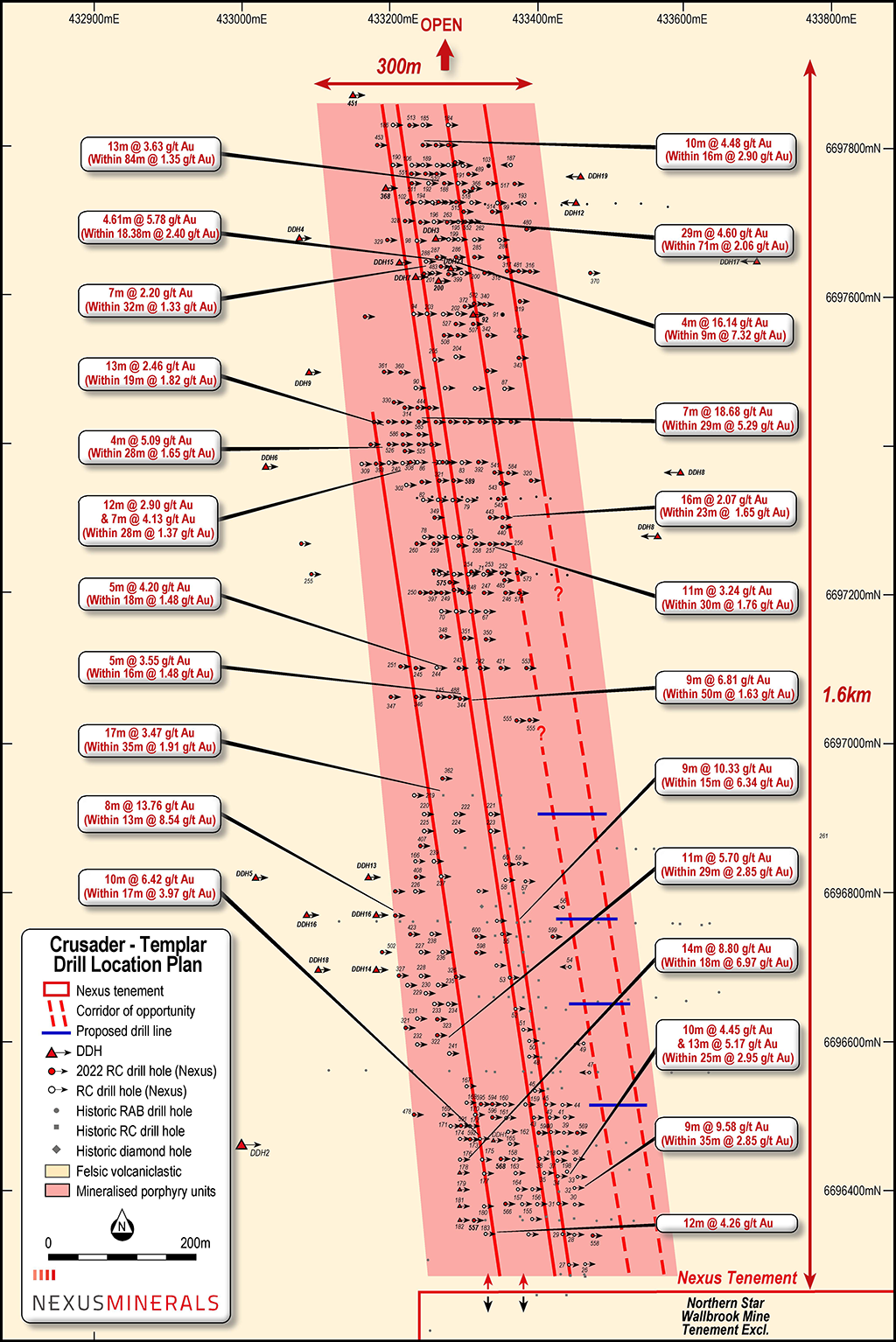
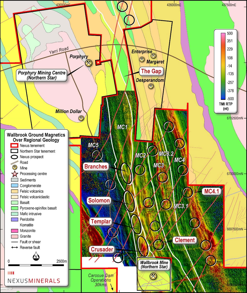
Crusader – Templar Prospect

Nexus announced on 26 April 2023 (refer to ASX release) the Crusader – Templar Open pit Mineral Resource Estimate (MRE) and the Exploration Target.

  • A JORC 2012 Exploration Target has been completed for the Crusader-Templar gold deposit
  • The Crusader-Templar Exploration Target is inclusive of the JORC 2012 Crusader-Templar Open Pit combined Mineral Resource Estimate (MRE) of:

    • 2.57 Mt @ 2.12g/t Au for 175,000 ounces contained gold (1g/t cut-off), including:
    • Indicated: 1.02 Mt @ 2.5g/t Au for 81,000 ounces contained gold
    • Inferred: 1.55 Mt @ 1.9g/t Au for 94,000 ounces contained gold
  • The MRE has focused on mine constrained open pit potential only and includes a significant component of indicated material comprising 46% of overall mineral resource
  • The MRE, with reasonable prospect of eventual economic extraction factors applied, is only a small component of the larger Exploration Target delineated by the extensive drilling undertaken
  • Preliminary mine studies have focused on potential for a low-risk, high margin open pit operation
  • The MRE is within the larger deposit that remains open to north and south along strike, down plunge of higher-grade shoots, and has potential for parallel lodes to the east
  • The MRE is supported by critical technical benefits including strong metallurgical recoveries of 98%, clear environmental studies, granted mining tenure and location next to Northern Star Resources mine infrastructure and nearby Carosue Dam mill
  • Systematic exploration of project is ongoing with potential to build the projects ounce portfolio over short, medium, and longer term – target pipeline offering Gold Camp opportunity and potential for operational longevity

Exploration Target

wallbrook2023-exploration
Note: The potential quantity and grade of the Exploration Target is conceptual in nature and as such there has been insufficient exploration drilling conducted to estimate a mineral resource. At this stage it is uncertain if further exploration drilling will result in the estimation of a mineral resource. The Exploration Target has been prepared in accordance with the JORC Code (2012).

Nexus undertook major drilling campaigns in 2022 across the 1.6km strike identified to date. Drilling included 68,951m of reverse circulation (RC) drilling and 14,679m of diamond drilling (DD).

The RC drilling was designed to test three main target depths, with a drill rig capacity of 250m vertically. The three zones are:

  • Oxide mineralisation – Surface to 100m
  • Transition mineralisation – 100 – 175m
  • Fresh rock mineralisation – 175 – 250m

The diamond drill program was designed to test for the mineralised sub-vertical porphyry units at depths of >250m, with the intersections used to inform the RC drill program hole locations. These mineralised porphyry units have been mapped from near surface to >600m vertical depth.

Other project work completed included:

  • Metallurgical Testwork – on oxide and fresh rock samples with high gold recoveries recorded for both the oxide material (98%) and the fresh rock (97.6%); and
  • Flora/Fauna survey – completed with no issues raised.

Examples of RC drilling results (in depth order) include:

Shallow Oxide Mineralisation <100m incl:

  • 14m @ 2.44g/t Au and 33m @ 2.09g/t Au (within 84m @ 1.35g/t Au from 9m);
  • 11m @ 5.35g/t Au (within 77m @ 1.36g/t Au from 14m);
  • 7m @ 2.78g/t Au (within 22m @ 1.02g/t Au from 26m);
  • 10m @ 4.48g/t Au (within 16m @ 2.90g/t Au from 31m);
  • 7m @ 18.68g/t Au (within 29m @ 5.29g/t Au from 31m);
  • 9m @ 7.30g/t Au (within 19m @ 3.81g/t Au from 43m);
  • 5m @ 3.55g/t Au (within 16m @ 1.48g/t Au from 70m);
  • 12m @ 1.72g/t Au (within 18m @ 1.21g/t Au from 75m); and
  • 5m @ 4.96g/t Au (within 12m @ 2.15g/t Au from 91m).

Transition Mineralisation 100-175m:

  • 16m @ 2.07g/t Au (within 23m@1.65g/t Au from 102m);
  • 20m @ 4.60g/t Au (within 33m @ 2.96g/t Au from 110m);
  • 5m @ 4.65g/t Au (within 9m @ 2.88g/t Au from 123m);
  • 3m @ 5.78g/t Au (within 15m @ 2.22g/t Au from 143m);
  • 2m @ 5.76g/t Au (within 6m @ 1.97g/t Au from 147m);
  • 6m @ 5.86g/t Au (within 19m @ 2.41g/t Au from 150m); and
  • 3m @ 8.77g/t Au (within 7m @ 4.15g/t Au from 177m).

Deeper Primary Mineralisation >175m

  • 4m @ 7.09g/t Au from 188m
  • 4m @ 16.14g/t Au (within 9m @ 7.32g/t Au from 203m);
  • 3m @ 4.17g/t Au (within 71m @ 0.51g/t Au from 228m);
  • 7m @ 4.13g/t Au (within 12m @ 2.90g/t Au from 245m);
  • 3m @ 11.40 and 4m @ 9.65g/t Au (within 37m @ 2.10g/t Au from 252m); and
  • 8m @ 13.76g/t Au (within 13m @ 8.54g/t Au from 267m).
Figure 3: Crusader-Templar Prospect Long Section – Selected RC drill results
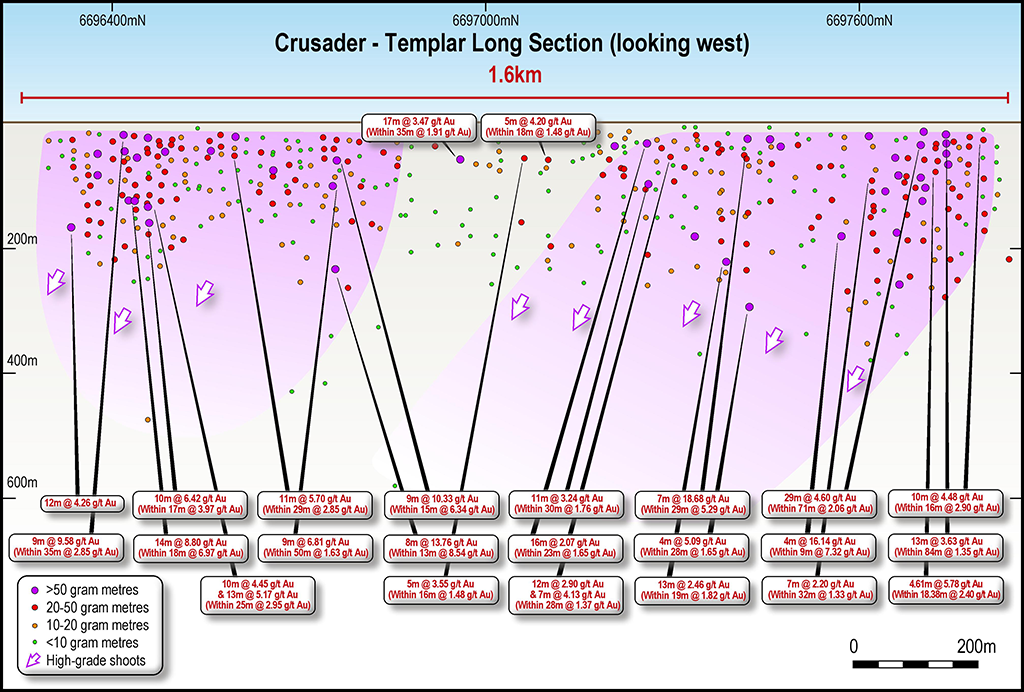
(Yellow boxes are recent diamond drill results / White boxes Nexus RC drill results)
Figure 4: Crusader Templar Drill Location Plan

Regional Exploration

Initial regional drilling has concentrated on the Branches and Solomon Prospects. Solomon lies 800m north of Templar, with Branches a further 2km north. These prospects sit on mineralised corridor 1 (MC1) that has been defined over 5km in length and some 300m wide. The mineralised corridor remains completely open at depth and to the north, where Nexus tenure continues along strike for a further 5km to beyond The Gap Prospect.

In a parallel mineralised corridor, the newly named Clement Prospect is located 500m to the east of the Crusader-Templar prospect on the next mineralised corridor 2 (MC2). An RC drill program was completed at Clement and encouragingly, sheared and hematite altered mineralised quartz porphyry units were intersected. Corridors MC3, MC4 and MC5 remain largely untested.

The results from the Company’s ground magnetics and gravity geophysical surveys continue to be integral in locating the favorable structural settings that host the region mineralisation.

Wallbrook exploration
Figure 5: Wallbrook Regional Prospects over Ground Magnetics and Geology

Branches Prospect

The Branches Prospect mineralisation is associated with sheared and hematite altered mineralised quartz porphyry units – “the right rocks”. These are the same rocks that host the gold mineralisation at the Company’s Crusader-Templar Prospect located 3km to the south and Northern Star’s multi-million ounce Carouse Dam Gold Project a further 30km to the south.

Significant Branches drilling results (in depth order) include:

  • 4m @ 6.37 g/t Au & 7m @ 4.34 g/t Au (within 36m @ 2.40 g/t Au from 18m)
  • 8m @ 2.64 g/t Au & 2m @ 3.19 g/t Au (within 34m @ 1.02 g/t Au from 20m)
  • 4m @ 3.40 g/t Au & 7m @ 2.71 g/t Au (within 30m @ 1.31 g/t Au from 25m)
  • 12m @ 5.21g/t Au (within 24m @ 2.23g/t Au from 25m);
  • 8m @ 3.65 g/t Au (within 27m @ 1.16g/t Au from 26m);
  • 3m @ 4.21 g/t Au (within 27m @ 1.19g/t Au from 27m);
  • 5m @ 3.45 g/t Au (within 16m @ 1.23g/t Au from 38m);
  • 5m @ 5.45 g/t Au and 3m @ 6.07g/t Au (within 36m @ 2.04g/t Au from 43m);
  • 8m @ 7.59 g/t Au (within 25m @ 2.86g/t Au from 43m);
  • 4m @ 7.47 g/t Au (within 8m @ 3.96g/t Au from 73m);
  • 6m @ 3.95 g/t Au (within 31m @ 1.31g/t Au from 113m);
  • 4m @ 7.23 g/t Au (within 10m @ 3.33g/t Au from 115m);
  • 5m @ 17.91 g/t Au (within 8m @ 11.37g/t Au from 118);
  • 1m @ 16.35 g/t Au (within 6m @ 3.10 g/t Au from 120m)
  • 3m @ 3.90 g/t Au (within 8m @ 1.51g/t Au from 124m).
Figure 6: Branches Prospect Drill Hole Location Plan

SOLOMON Prospect

At the Solomon Prospect, located 800m north of Templar, drilling has intersected similar host rocks and alteration styles to those observed in the Crusader-Templar mineralised corridor. That being a hematite altered / silicified quartz porphyry that has intruded a volcaniclastic host rock unit. Recent results include:

    • 10m @ 3.40g/t Au (within 22m @ 1.88g/t Au from 123m);
    • 3m @ 4.69g/t Au (within 26m @ 1.06g/t Au from 258m);
    • 3m @ 1.79g/t Au (within 6m @ 1.06g/t Au from 34m);
    • 2m @ 1.55g/t Au (within 8m @ 0.52g/t Au from 43m).
Figure 7: Photo : Hole #449: 10m @ 3.40g/t Au (within 22m @ 1.88g/t Au from 133m)