Wallbrook Gold Project
The 192km2 Wallbrook tenement package is considered highly prospective for the discovery of significant gold mineralisation.
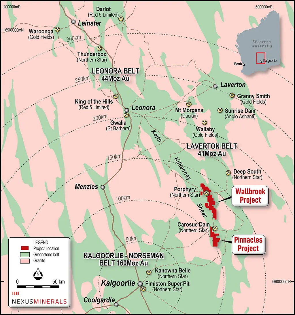
Located 130km north east of Kalgoorlie
The Wallbrook tenement package covers 192km2 and is an amalgamation of tenements acquired from Newmont and Saracen Minerals in 2018.
In November 2018, Nexus completed a Tenement Sale and Purchase Agreement to acquire from Newmont the surrounding 190km2 tenement package adjacent to Nexus’ existing 60km2 Wallbrook Gold Project. Nexus acquired from Newmont the surrounding three tenements covering 190km2 for a total consideration of $13,100 and a 2% net smelter royalty on all mineral product extracted and recovered from the tenements (ASX release 29 November 2018 – Nexus Completes Wallbrook Tenement Acquisition from Newmont).
Nexus had previously acquired the central Wallbrook exploration tenements from Saracen, in January 2018 for consideration of 1,490,000 Nexus shares (ASX release 23 January 2018 – Nexus Wallbrook Gold Project Update).
Regional and Local Geology
The Wallbrook Project occurs within the Norseman – Wiluna Archaean Greenstone belt in the Eastern Goldfields province of the Yilgarn Craton. The Project is located within the Edjudina Region in the Laverton Tectonic Zone, centrally between Kalgoorlie and Laverton, and 35km north of Northern Star Limited’s Carosue Dam Gold Mining Operation.
The granite-greenstone belt is approximately 600 kilometres in length and is characterised by thick, possibly rift-controlled accumulations of ultramafic, mafic, felsic volcanic, intrusives and sedimentary rocks. Greenstone successions of the southern Eastern Goldfields have been segregated into elongate structural terranes bounded by regional NNW-trending faults (Swager, 1995). These terranes include the Kalgoorlie Terrane, Gindalbie Terrane, Kurnalpi Terrane and the Edjudina Terrane. These terranes contain distinct similarities, including timing of the deposition of volcano-sedimentary sequences (2720-2675 Ma) and regional deformation and plutonism (2675-2620 Ma). The terranes differ only in lithostratigraphic development and early tectonic history (Swager, 1995).
The Wallbrook Project area is located between two major converging tectonic features, the Laverton and Keith-Kilkenny tectonic zones. The Laverton Tectonic Zone (LTZ) forms the central portion of the Laverton Greenstone Belt, running north-south in the eastern parts of the Wallbrook Project. The LTZ is recognized as a world class gold province, with a mineral endowment (production + resources) of over 20 Moz of gold. Major deposits include Sunrise Dam (8.0 Moz), Wallaby (8.0 Moz) and Granny Smith (3.6 Moz). The Keith-Kilkenny Tectonic Zone (KKTZ) has a northwest-southeast orientation and is an important vector to mineralisation in the region between Leonora and Leinster. The southern extension of the KKTZ intersects the Carosue Dam Operation (4.275 Moz).
The lithologies at Wallbrook are dominated by intermediate (andesitic) volcanics, intrusive felsic porphyries and granite. The dominant feature in the project area is the Wallbrook Monzonite. North of the monzonite are relatively smaller granitic intrusions and related narrow felsic porphyry dykes/sills which run predominantly parallel to the regional trend.
The project area covers the convergence of two major trends wrapping around the northern end of the tear-shaped Wallbrook Monzonite. There are several phases of alteration observed, including:
- chlorite + magnetite (associated with regional deformation);
- hematite + silica + sulphides (+ associated felsic intrusives); and
- sericite + silica + carbonate + pyrite + gold (late tectonic + mineralising event).
As with many of the gold deposits within the Eastern Goldfields, gold mineralisation occurred relatively late in the deformational history of the area. Within the felsic lithologies there is a relationship between the hematite/silica alteration and gold mineralisation. Arnold (1999) suggests gold mineralisation is related to hematite bearing oxidized alteration assemblages, with deposition occurring where gold bearing fluids have come into contact with earlier magnetite-hematite assemblages.
Recent Wallbrook Announcements
- Annual Report to shareholders 2026 - September 23, 2026
- Company Presentation - September 21, 2026
- A$5.4 Million Placement to Advance Wallbrook Gold Project - September 21, 2026
- NEXUS GROUP RESOURCES INCREASE TO 709,000OZ GOLD - September 17, 2026
- New High Grade Crusader Lode Returns 3m @18.75g/t Au - September 01, 2026
- Hi-Grade Drill Results up to 41.27g/t Au at Templar Prospect - August 18, 2026
- Company Presentation - Diggers & Dealers - August 03, 2026
- Quarterly Activities/Appendix 5B Cash Flow Report - July 31, 2026
- Wallbrook Project- Branches RC Results Extend Mineralisation - July 29, 2026
- Further Hi-Grade Results at Payns Prospect up to 34.77g/t Au - July 15, 2026
- 1
- 2
- 3
- …
- 10
- Next Page »

WALLBROOK PROSPECTS
Wallbrook Gold Project
Nexus announced the results of its Combined Mineral Resource Estimate (MRE) upgrade in September 2026 (ASX: 17th September 2026).
Wallbrook Resource combined MRE across the three deposits
13.3Mt at 1.5g/t Au for 631,000oz
- Indicated Mineral Resource of 4.3Mt at 1.5g/t Au for 207,000oz (33%)
- Inferred Mineral Resource of 9.0Mt at 1.5g/t Au for 424,000oz (67%)
- Resource increased by 108% from 304koz to 631koz
- Crusader–Templar Updated MRE – 10.8Mt at 1.5g/t Au for 533,000oz
- Payns Deposit Maiden MRE – 1.2Mt at 1.3g/t Au for 50,000oz
- Branches Deposit Maiden MRE – 1.3Mt at 1.1g/t Au for 48,000oz
- ~90% of 192km2 tenement package yet to be explored
- Interim resource with advanced prospects Amand and Godfrey to be drilled to increase ounce portfolio
- Pipeline of untested regional targets remain across the tenure
- Scoping study of mining inventory to support 350ktpa gold plant build
Crusader–Templar Deposit Updated MRE (incl Clement)
10.8Mt at 1.5g/t Au for 533,000oz
- Indicated material comprising 39% of the MRE
- Crusader-Templar remains open at depth and along strike has potential for repeat structures to the East
- Metallurgical test work returned high gold recoveries Oxide 98% / Fresh 97.6%
- MRE within optimised open-pit Reasonable Prospect for Eventual Economic Extraction (RPEEE) shell – using A$6000 gold price
- Granted Mining Lease – Flora & Fauna and Heritage surveys cleared Opportunity exists for low risk, high margin open pit mining operation
- Abuts Northern Star operating Wallbrook Gold Mine
- Deposit exceeds 530,000oz including an underground of 4Mt at 1.9g/t Au for 86,000oz beneath the optimised pit shell
- The grade continues to increase at depth with higher grade in the underground component
Regional Exploration
Nexus has been undertaking a systematic exploration strategy at the Wallbrook Gold Project, successfully establishing the foundations of a significant, emerging gold camp in one of Western Australia’s premier mining districts. The Company has progressed a regional exploration strategy driven by targeted AC and RC drilling programs.
This regional effort has now defined five prospects – Branches, Payns, Clement, Amand and Godfrey – each advancing toward a Resource Definition exploration phase. These prospects collectively display large, mineralised footprints, all remaining open along strike and down dip (Table 3).
- Branches – 1,500m x 300m footprint situated 3km north of the Crusader-Templar Deposit
- Payns – 650m x 250m footprint situated south along strike of operating mines
- Clement – 900m x 750m footprint adjacent to the Crusader-Templar Deposit and immediately north of operating mine
- Amand – 1,700m x 600m footprint south along strike of historical mines
- Godfrey – 1,200m x 100m footprint forming part of the broader Crusader-Templar system
Payns Deposit
Maiden Mineral Resource
1.2Mt at 1.3g/t Au for 50,000oz
- Footprint of 900m x 750m open at depth and along strike, approximately 4km northeast of Crusader
- Payns resource sits near surface, shallowing dipping “bowl like” deposit which is favourable for open pit mining
- Currently two pits with the potential for further future drilling to combine into one larger open pit
- Payns resource sits near surface, shallowing dipping “bowl like” deposit which is favourable for open pit mining
Branches Deposit
Maiden Mineral Resource
1.2Mt at 1.3g/t Au for 50,000oz
- Footprint of 900m x 750m open at depth and along strike, approximately 4km northeast of Crusader
- Payns resource sits near surface, shallowing dipping “bowl like” deposit which is favourable for open pit mining
- Currently two pits with the potential for further future drilling to combine into one larger open pit
- Payns resource sits near surface, shallowing dipping “bowl like” deposit which is favourable for open pit mining